Burgess Hill’s lost and standing heritage

1, William Meeds House

2,The Junction Inn

3, Open-Air swimming pool

4, St Johns Institute
5, The Potters Arms
6, Hoadleys Department Store

7, Burgess Hill Farm
8, Leylands Farm

9, Bedelands Farm

10, St Johns Common

11, Burdocks Farm

12, West End Farm
1, William Meed’s – lost urban heritage
William Meeds’ house in Station Road: The former brickmaker William Meeds died in 1904. He had been the owner of the adjacent brick, tile and pottery works, known as ‘Meeds’. The firm was a prolific producer of decorative terracotta, among which were the two urns and their pedestals standing in the front garden. The works carried on trading until the 1950s and his house was an attractive landmark in Station Road for another feature house was demolished in 2011 to make way for a small housing development in Station Road and Queen Elizabeth Avenue.
2, The Junction Inn – lost urban heritage
The Junction Inn by the level crossing in Junction Road. It was built in the mid-19th century after the Lewes branch line was opened and a little ‘Halt’ was constructed nearby for users of the line. It was at another junction near London Bridge Station in 1909 that the inventor John Saxby was inspired to design his “pointlock” system to prevent accidents at junctions. His first “pointlock” was installed here at Keymer Junction. The signal box which can be seen in the photo was pulled down when an automatic system was introduced. The site is now a local Co-op store.
3, Open Air swimming pool – lost urban heritage
The Open-Air Swimming Pool in St. John’s Park. Financed by the local council was opened in 1935, it became a popular destination for local people of all ages. In the 1970s a second, indoor pool was added which was heavily used by local schools for swimming lessons. The complex was demolished in 1999 when the Triangle Leisure Centre, a new multi-sports complex, was opened. Because so many local people had petitioned to keep the old outdoor pool, a small one was provided at the Triangle.
4, The St. John’s Institute – standing urban heritage
The St. John’s Institute, now ‘the Park Centre’: a community hub in Park Road at the north-east corner of St. John’s Park. It was erected in 1871-1874 by local builder Simeon Norman in distinctive red brick with cream banding, – the same as the house next door – but its fascia has since been extended and painted white. It was financed by the local benefactress Emily Temple and dedicated in her Will to the use of the Town for all time. Recently in danger of redevelopment, as the cash-strapped trustees, W. Sussex County Council made plans to sell it off, but instead are now developing it for youth activities.
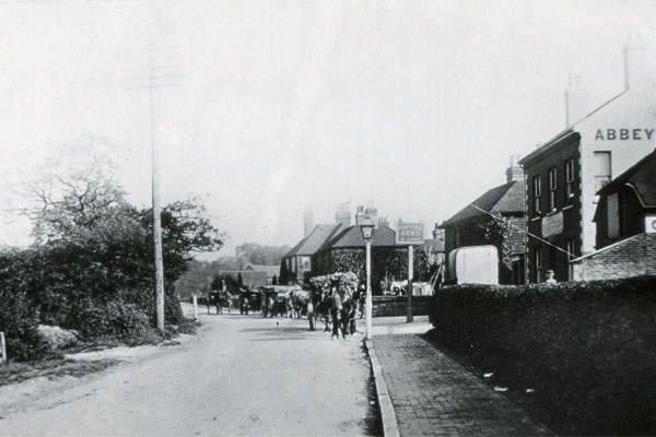
5, Potters Arms in Station Road – standing urban heritage
The Potters Arms in Station Road: In 1852 Edward Harmes, retired brickmaker of the adjacent potteries, later known as Meeds, sold the land for the pub to William Hallett, a brewer of Brighton. Hallett had in fact already built the pub there, with the help of a mortgage from the ‘Borough the of Brighton Building Society’. The carts in the road when the shot was taken were probably engaged in transporting the products of the brick yard. The pub’s main clientele in those early days were the brickmakers and potters next door, but with the land to the south being developed for housing from the 1950s onwards, it is still in business.
6, Hoadleys Department Store – standing urban heritage
Hoadley’s Department Store: The business that was to become our town’s first and only department store was founded by F. W. Hoadley in 1857. From then on, as the upper middle classes flocked to build grand new houses on the hill, so did the shop expand to serve them, becoming a prominent landmark at the top of the hill at ‘Hoadley’s corner’. It was still a thriving department store in the 1960s and 1970s but gradually retracted as local shopping focused on the new pedestrianised areas of the town. It ceased trading in 1983 after 126 years of business. Happily, the building itself will live on as a landmark as it is currently being converted into flats.
7, Burgess Hill Farm – lost rural heritage
Burgess Hill Farm, formerly standing just downhill from the Railway Station: It was a rich meadowland farm of 128 acres, occupied since before the Norman Conquest of 1066 which was developed for housing from the 1950s as the Chanctonbury Road Estate, while the meadows accommodated the buildings and playing fields of the former comprehensive school, Oakmeeds, now known as Burgess Hill Academy and, formerly Oakmeeds School. The predominately brick farmhouse was built circa 1650, replacing an earlier house. The farming tenant had then started to produce bricks and tiles on his land as a sideline.
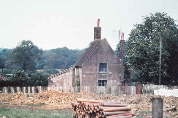
8, Leylands Farm – lost rural heritage
Leylands Farm, one of the late-Anglo-Saxon or early Norman woodland clearances for settlement. In the medieval period it would have been the home of a small subsistence-farming family. Throughout its history and into the 20th century it remained as a modest 30-acre ‘copyhold’ farm held of the manor of Keymer named Leylands, which means ‘land at the woodland clearings’. Along with a neighbouring ‘cottage’ plot of 12 acres called Coopers, it was sold when the eastern part of Maple Drive and Coopers Close were about to be built. The photo shows it at that point in time, when demolition was imminent.
9, Bedelands Farmhouse – lost rural heritage
The land of Bedelands is now a Nature Reserve, visited daily by local residents and others. From the time when the manor of Keymer was created (around the 10th century) the Beadle was given a 10-acre holding at a reduced rent in return for holding that office. His main duty was to collect the rents of all the smaller land holdings (5-10 acres or so) in the manor and known as ‘cottages’. By the time this house was built , three 3 local ‘cottage’ holdings had merged to form the 30-acre ‘farm’ known as Bedelands. The house stood on the south west side of Valebridge Common and south of the Lord of the manor’s ‘Big Wood’, both of which were added to the Reserve.
10, St. John’s Common – standing rural heritage
St. John’s Common Open Space: part of the southern boundary of this area (a western extension to Fairfield Rec.), is an impressive curved hedgerow. It is in fact the boundary of one of our very earliest known brick and tile making plots, in the days when brickyards were small and rural. The site is now called ‘The Gattons’, where the primary School of that name has since been built. It was enclosed out of the common around 1584, perhaps by the Lord of Clayton manor himself and leased to a small rural producer, probably on a 100-year lease. It was snapped up by Sir Richard Michelborne of Hammonds in Burgess Hill in 1684 and will certainly have produced some of the brick and tile that were later used to enlarge that house.
11, Burdocks Farm – standing rural heritage
Burdocks Farm: This was part of a land-settlement project, probably in the 1200s when population was rising, by the lords of Lewes Barony who owned Ditchling manor and its great wood of Frekebergh. This wood had been a ‘free chase’, once owned by King Alfred the Great when he was lord of Ditchling Manor. We fed this information to local authorities when the Folders Lane Estate was being developed, which is why the word ‘King’s…..’ appears there in the modern road names. The farmhouse is a post-medieval rebuild whose outer wall is enhanced by some locally-produced terracotta.
12, West End Farm – standing rural heritage
West End Farm: The old farmhouse in the centre foreground of the photo is now the Woolpack public house, and the fields are now part of Howard Avenue and the roads which radiate from it. The original farm was a late-Saxon, up-Wealden hamlet in the manor of Wickham (by Stonepound Crossroads, Hassocks). It stretched west as far as our Leisure Centre, The Triangle, and north to the banks of the river Adur. In those early days it was formed of three 30-acre customary holdings called Floods Hatch, Collins and Westup who would all have shared one plough in the earliest times. The Woolpack stands on the plot formerly known as Floods Hatch.